

Cloudbursts Trigger Deadly Floods in Pakistan and India
This monsoon season, both Pakistan and India have experienced intense and sudden rainfall events known as cloudbursts, resulting in hundreds of fatalities due to flash floods and landslides.
A widely recognized definition describes a cloudburst as rainfall exceeding 100mm (4 inches) within a single hour over a localized area.
The current monsoon season, originating in the Bay of Bengal and progressing westward across northern India towards Pakistan each summer, has been marked by these devastating cloudbursts.
Meteorological studies suggest that cloudbursts in South Asia typically arise when warm, moisture-laden monsoon winds encounter colder mountain air in northern regions of India and Pakistan, leading to condensation. With the increasing global temperatures, the monsoon air is warmer and capable of holding more moisture.
Data from India’s weather authorities indicate that cloudbursts are most prevalent in the Himalayan areas.
Fahad Saeed, a climate scientist based in Berlin, noted that in the northern mountains of Pakistan, the warm monsoon system from the east converges with colder air from the west, influenced by the subtropical jet stream originating in the Mediterranean.
He added that global warming is causing this jet stream to shift further south during summer, allowing it to interact with lower-level monsoon clouds in Pakistan, creating massive cloud formations that release torrential rainfall.
Similar intense rainfall events, albeit triggered by varying local conditions, occur globally. An example is the Texas floods in July, where over 300 mm of rain fell in under an hour, generating a surge of water in the Guadalupe River.
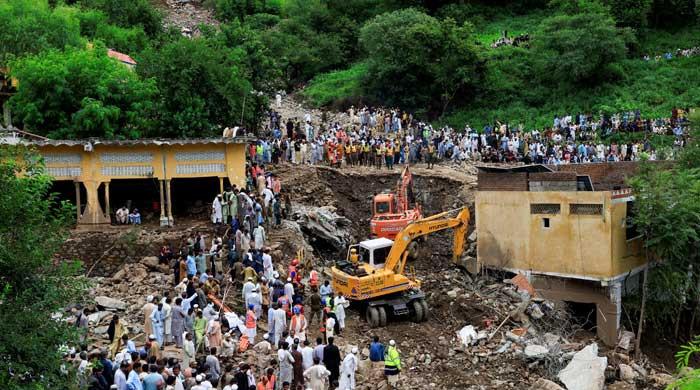
This monsoon season has witnessed at least four significant deadly cloudbursts, including one in Uttarakhand, India, where a video captured buildings being swept down a mountainside, and another in Buner, within Pakistan’s Hindu Kush range, where over 200 individuals perished following at least 150mm of rainfall within an hour.
S D Sanap, a scientist at the India Meteorological Department’s Pune office, mentioned that such cloudburst occurrences are becoming more frequent in the western Himalayas, which traverse both India and Pakistan. However, attributing this increase to a single factor remains challenging.
Moetasim Ashfaq, a US-based weather expert, stated that the cloudburst events on both sides of the border were triggered similarly: by very moist monsoon air, upslope winds, and storms that lingered over valleys.
Pradeep Dangol, a senior hydrology research associate at the International Centre for Integrated Mountain Development in Nepal, explained that if a cloudburst occurs over flat terrain, the rainfall spreads across a larger area, lessening the impact.
However, in steep mountain valleys, the rainfall is concentrated into confined streams and slopes, increasing the risk of flash floods and landslides.
Sanap noted that forecasting these events days ahead is nearly impossible, although radars can monitor the formation of dense cloud masses and provide short-term warnings of intense rainfall.
To enhance monitoring, the India Meteorological Department has deployed new radars throughout the Himalayas and established observatories to improve early warnings and understanding of these severe weather phenomena.
Syed Muhammad Tayyab Shah, who is in charge of risk assessment at Pakistan’s National Disaster Management Authority, stated that while it is feasible to issue warnings for general areas, pinpointing the exact location of a cloudburst in advance is not possible.
Comments (0)
No comments yet. Be the first to comment!
Leave a Comment